
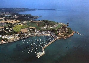
Gorey
Latitude: 49° 11'N
Longitude: 02° 00'W
Country: Channel Islands
Ownership: States of Jersey
Type: Municipal
Usage: Leisure, Fishing, Commercial
Contact name: Capt. Howard Le Cornu, Harbourmaster
Address: Maritime House, La Route du Port Elizabeth, St Helier, Jersey JE1 1HB
Telephone no: 01534 447788
E-mail: jerseyharbours@gov.je
Website: www.portofjersey.je/Jerse...bours.aspx
About Gorey
Gorey harbour is a tidal harbour situated on Jerseys east coast. A new pier was built in 1816 for the benefit of the boats serving the growing oyster industry. It is the nearest harbour to the French coast and Jersey's second port. It provides moorings and shelter to over 240 local vessels. This number is mainly made up of private pleasure craft, although a number of smaller commercial fishing vessels also reside there.Visitor holding buoys are available at the south western edge of the harbour, with a handful of upper beach moorings available during the summer season.
Return to Area Map