
Image © Guernsey Harbours
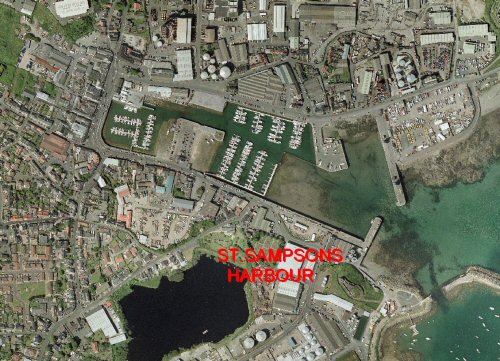
St Sampson
Latitude: 49° 28'N
Longitude: 02° 30'W
Country: Channel Islands
Ownership: Guernsey Harbours
Type: Municipal
Usage: Leisure, Fishing, Commercial
Contact name: Capt. Peter Gill, Harbour Master
Address: P.O. Box 631 St Julians Emplacement, St Peter Port, Guernsey, GY1 3DL
Telephone no: 01481 720229
E-mail: guernsey.harbour@gov.gg
Website: www.guernseyharbours.gov.gg/
About St Sampson
Towards the end of the 18th century there was a demand for granite in England and around 1760 granite was stating to be exported from the island. Ships would dry out and be loaded by horse and cart from the nearby quarries that were starting up to supply the demand. The granite industry built into a flourishing trade and as it did St Sampsons expanded.By 1790 a breakwater had been built out from Mont Crevelt to provide more shelter. An oyster trade also operated out of the haven.
Around 1806 the Braye du Valle was filled and from 1820 St Sampsons slowly started developing as a harbour. It continued growing right through the 1800s keeping the design and layout that remained for 200 years; the inner harbour has since been redesigned and provides a modern 350 berth leisure craft marina facility.
A second industry had built up during this earlier period, shipbuilding, and no fewer than seven yards operated around St Sampsons between 1815 and 1895. Guernseys boat-building quality was renowned throughout the world.
St Sampsons has always operated as a commercial port, bringing in coal, wood, oil, cement and many other necessities into the island and continues to do so today. Around 350 cargo vessels still deliver to it each year and boat repairs and maintenance are still carried out.
Return to Area Map