
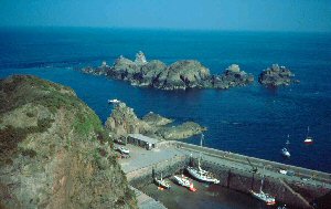
Creux (Sark)
Latitude: 49° 26'N
Longitude: 02° 20'W
Country: Channel Islands
Ownership: Isle of Sark Harbours Committee
Type: Private
Usage: Leisure, Fishing
About Creux (Sark)
The first harbour at Creux was built in 1588 by the first settlers, but the present harbour dates from 1868, the winter storms of 1865/6 destroying the original walls.The picturesque old harbour is now used mainly by fishermen and yachtsmen, or by ferries which cannot enter Maseline Harbour due to adverse conditions. There is also a small enclosed beach reached via a tunnel in the rock.
The famous Sark Water Carnival is held at Creux in mid summer.
Return to Area Map