
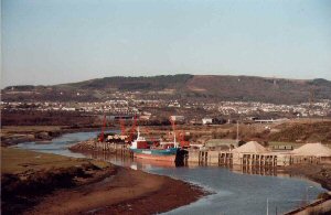
Briton Ferry (Neath)
Latitude: 51° 37'N
Longitude: 03° 49'W
Country: Wales
Type: Private
Usage: Commercial
Contact name: Andrew Williams, Chief Executive
Address: Briton Ferry Stevedoring Ltd., Giant's Wharf, Briton Ferry, Neath, S. Glamorgan, SA11 2LP
Telephone no: 01639 825700
E-mail: bfss@dial.pipex.com
Website: www.britonferryshipping.c.../index.php
About Briton Ferry (Neath)
Briton Ferry, a seaport in the mid-parliamentary division of Glamorganshire, Wales, on the eastern bank of the estuary of the Neath river in Swansea Bay, with stations on the Great Western and the Rhondda & Swansea Bay railways, being 174 m. by rail from London. The district was formerly celebrated for its scenery, but this has been considerably marred by industrial development which received its chief impetus from the construction in 1861 of a dock of 13 acres, the property of the Great Western Railway Company, and the opening up about the same time of the mining districts of Glyncorrwg and Maesteg by means of the South Wales mineral railway, which connects them with the dock and supplies it with its chief export, coal.The name La Brittone was given by the Norman settlers of the 12th century to its ferry across the estuary of the Neath (where Archbishop Baldwin and Giraldus crossed in 1188, and which is still used), but the Welsh name of the town from at least the 16th century has been Llansawel.
Return to Area Map