
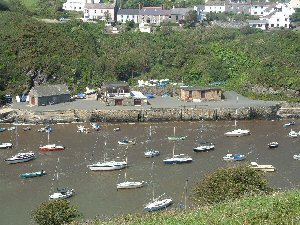
Solva
Latitude: 51° 52'N
Longitude: 05° 12'W
Country: Wales
Type: Unknown
About Solva
Solva, an ancient fishing village, whose Viking name means 'sunny inlet' stands in a deep valley gouged out by water melting from glaciers, and its position made it ideal as a base for trading ships in the 18th century. It grew from the lime trade, which was very much a cottage industry, fed by ships calling at almost every little bay and inlet. The limekilns still stand today.Its fiord-like harbour is ideal for boating - a safe haven for yachts on the rocky St. David's peninsula. Today it is a popular family resort.
Return to Area Map