
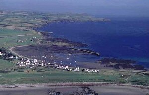
Derbyhaven
Latitude: 54° 05'N
Longitude: 04° 36'W
Country: Isle of Man
Ownership: Isle of Man Harbours
Type: Municipal
Usage: Leisure
Contact name: Capt Michael Brew, Director of Harbours
Address: Sea Terminal Building, DOUGLAS, Isle of Man, IM1 2RF
Telephone no: 01624 686626
E-mail: michael.brew@harbours.dot.gov.im
Website: www.gov.im/harbours/DerbyhavenPort.asp
About Derbyhaven
A shallow water bay sheltered by an island breakwater, Derbyhavens south eastern position makes it ideal for leisure craft, but not suitable for commercial vessels. The bay is in a picturesque setting alongside the Castletown Golf Links championship course and hotel. The bay is a favourite on the Island for windsurfers.Return to Area Map