
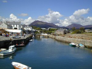
Annalong
Latitude: 54° 06'N
Longitude: 05° 52'W
Country: N. Ireland
Ownership: Newry and Mourne District Council
Type: Municipal
Usage: Leisure, Fishing
Telephone no: 0283 031 3031
About Annalong
Recent redevelopment as part of the Fishing Villages Programme (1994) has seen significant works including the deepening of the harbour approach channel and basin, the replacement of the surge gate and the installation of a floating pontoon for leisure craft.The new facilities allow 24-hour access, providing safe and secure berthing for local boats and visitors.
Return to Area Map