
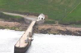
Graemsay
Latitude: 58° 56'N
Longitude: 03° 16'W
Country: Scotland
Ownership: Orkney Islands Council
Type: Municipal
Usage: Ferry Terminal
Contact name: Capt. Nigel Mills, Director of Harbours
Address: Harbour Authority Building, Scapa, Orkney, KW15 1SD
Telephone no: 01856 873636
E-mail: harbours@orkney.gov.uk
Website: www.orkneyharbours.com/gr...y_pier.asp
About Graemsay
An island in the western approaches to Scapa Flow in the Orkney Isles, Graemsay lies between the Mainland of Orkney and the island of Hoy. Rising to a height of 62m (203 feet) at West Hill, the island has an area of 409ha (1011 acres) and a population of 27 crofters and fishermen. Graemsay is linked by ferry to Stromness and Hoy, its pier being located on the east coast southeast of the Hoy High Lighthouse on the Taing of Sandside. Although the ferry is ro-ro, the pier is not, so only passengers can travel, with everything else being winched on or off on the thrice-weekly cargo runs; that includes livestock, cars, oil for the heating system, diesel etc.Both the Hoy High and Low Lighthouses were built in 1851 to safeguard the herring fleet sailing the dangerous waters of the Hoy Sound. On New Year's Day 1866 the ship Albion was wrecked off Point of Oxan, the island's north western extremity. Although its school was closed in 1996, Graemsay has a post office and a shop.
Return to Area Map