
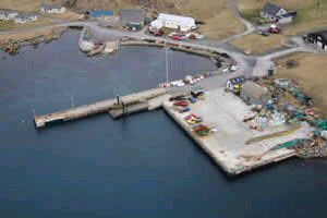
Bruray (Out Skerries)
Latitude: 60° 25'N
Longitude: 00° 45'W
Country: Scotland
Ownership: Shetland Islands Council
Type: Municipal
Usage: Leisure, Fishing, Commercial, Ferry Terminal
Telephone no: 01595 693010
Website: www.shetland.gov.uk/ports...erries.asp
About Bruray (Out Skerries)
OUT SKERRIES, lying twenty-four miles north-east of Lerwick, consists of three main islands Housay and Bruray, the east and west isles joined by the present bridge in 1957, and the uninhabited island of Grunay together with many other islets and rocks.The life of Skerries centres around the extraordinary natural harbour, protected on all sides and turning Böd Voe into a calm lagoon in even the most violent of storms.
On Fridays, Saturdays, Sundays and Mondays there is a ferry service from Vidlin; on Tuesdays and Thursdays the ferry departs from Lerwick. Passengers and vehicles must be booked by 5pm the previous evening. If no bookings are received, the ferry will not run.
Fishing has always been very important to the Skerries folk, and today several boats work from here. There is also a large communally-owned salmon farm.
Return to Area Map