
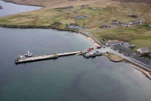
Mid Yell
Latitude: 60° 36'N
Longitude: 01° 03'W
Country: Scotland
Ownership: Shetland Islands Council
Type: Municipal
Usage: Leisure, Fishing
Contact name: Capt Jim Dickson, General Manager and Harbour Master
Address: Port Administration Building, Sullom Voe, Sella Ness, Shetland, ZE2 9QR
Telephone no: 01806 242551
E-mail: jim.dickson@sic.shetland.gov.uk
Website: www.shetland.gov.uk/ports...idyell.asp
About Mid Yell
Mid Yell is the largest settlement on Yell. The Vikings founded a settlement beside the inlet they called Reydarfjordur, probably in the 800s. By the 1500s this had become Refurd or Reafirthand, and the name of the settlement was later changed to Mid Yell. Fishing has been important to the village throughout its history, though it had only a wooden pier until the one you see today was built in 1953. The wooden pier had been used by steamers from Lerwick since the 1800s.Mid Yell Voe is deep and sheltered, and its attractions as a port continue today, though the direct steamers have long since been replaced by the short car ferry crossings. The mouth of Mid Yell Voe is protected from the weather by the uninhabited island of Hascosay.
Return to Area Map