
Snape Bridge
Latitude: 52° 08'N
Longitude: 01° 30'E
Country: England
Type: Private
Usage: Leisure
About Snape Bridge
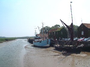
Probability suggests it was the monks from Snape Priory who constructed their own water mill and also built the first bridge across the Alde. It was certainly wooden and by 1492 sufficiently in need of repair for the then Bishop of Norwich to give permission for alms for that purpose to be sought from travellers.The River Alde played a more significant part of Snape's development than the railway. As a small inland port at the head of navigation, it was, with the growth of the Snape Maltings, by the end of the 19th century, a remarkably busy one.
It was by Thames barge from the port that, a hundred years ago, a significant cargo was sent to Holland. Sugar beet had not been successfully grown in this country before but a crop, planted on the field between the Crown and the river and shipped to the Netherlands for processing, proved that it could be made to pay. There was also a considerable trade in grain to the port of London and other markets. Snape was a busy port until 1859, when the railway came.
Nowadays no commercial craft come to Snape, but the occasional sailing barge makes it this far up the river. Other leisure craft tie up at the quay, from where it is but a short stroll to the famous Snape Maltings, where international concerts are held.
Return to Area Map