
Burnmouth
Latitude: 55° 51'N
Longitude: 02° 03'W
Country: Scotland
Ownership: Burnmouth Harbour Trust
Type: Trust
Usage: Leisure, Fishing
Contact name: Mr Alistair Affleck, Chairman of Commissioners
Address: c/o John Aitchison, Harbour Master, 16 Partanhall, Burnmouth, Eyemouth
Telephone no: 01890 781306
E-mail: j.aitchison021@btinternet.com
Website: www.undiscoveredscotland....index.html
About Burnmouth
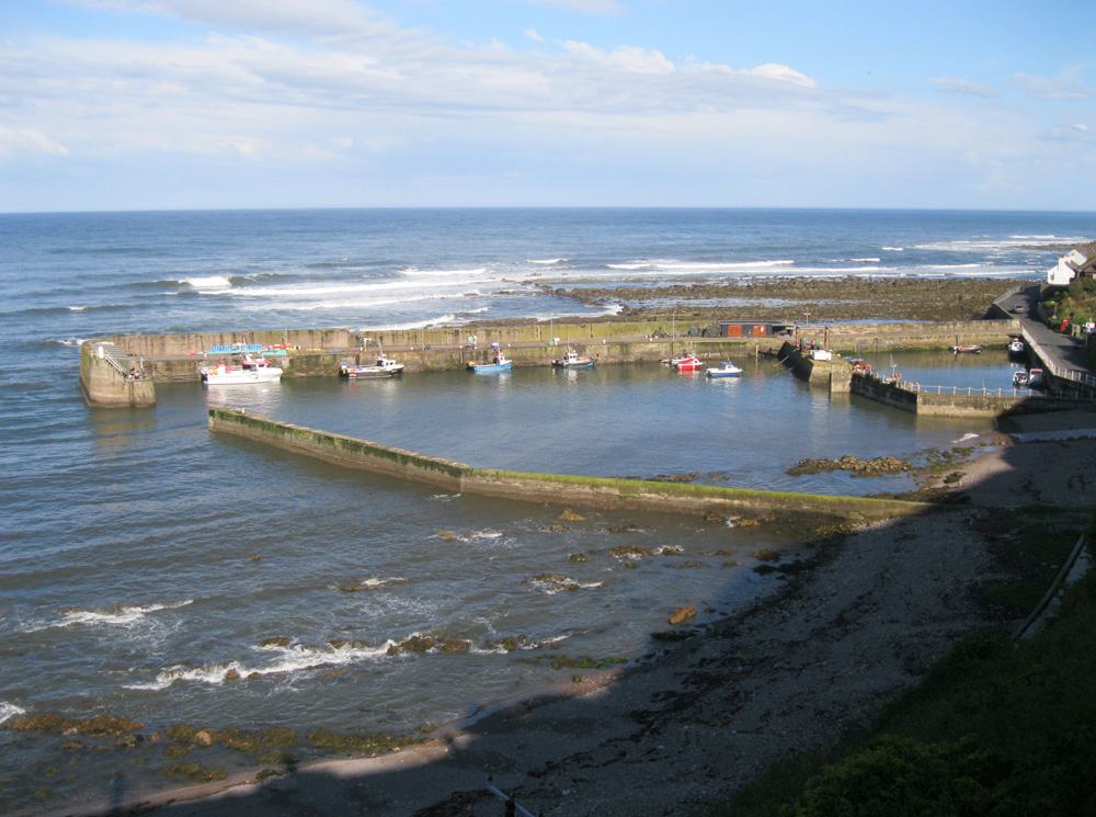
Lower Burnmouth is on the East coast of Scotland between Berwick and Eyemouth. It is the fishing village on the east coast of Scotland which lies closest to the English border. It is situated picturesquely at the foot of steep cliffs. Burnmouth Harbour was completed in 1878 at a cost of £9,000.Burnmouth Harbour Trust was formed by an Act of Parliament on 1894, but the harbour itself had probably been in existence for many years before the Act came into force. The Act provided for the appointment of a harbour master and the formation of a Trust consisting of elected members and ex-officio members from the local community such as local ministers, the local schoolmaster and local councillor etc.
During the 1800s and first half of the last century the main industry undertaken by the fishermen was inshore fishing for lobsters and edible crabs, known locally as poos. A shellfish market used to be held at the harbour from Monday to Friday. When the crab catch came in they would be stored in wooden boxes, called hullies, which would pack out the whole harbour; an occurrence known locally as hulling the poos. Some larger boats fished for herring and white fish much further from port, but these moved to Eyemouth harbour following developments there in recent decades.
Whilst men worked on the fishing boats, groups of women worked in the herring industry, gutting the fish when it arrived in Burnmouth harbour.
In the latter part of the last century the main industry has remained inshore fishing for shellfish although the number of boat has now declined to five. In a picture repeated throughout Berwickshire and North Northumberland as fish catches decline, there has been some diversification with fishermen catering for the leisure industry by taking out sea anglers and providing boat trips for tourists.
During the past two years major renovations have been undertaken to the harbour including the erection of fishermens stores and the installation of lifting gear and shellfish tanks and a general upgrading of the harbour with a view to sustaining the local traditional fishing industry, encouraging landings from fishing boats outwith the area and attracting yachts and pleasure boats.
The few men who fish from here still make a living from crab and lobster fishing. Most of them take anglers out in the summer which constitutes a vital additional source of money. Other fishermen commute from here to Eyemouth, where they work on one of the big trawlers which are based there.
Burnmouth itself comprises a group of 5 hamlets. Part of it lies at the foot of a deep ravine beside the harbour sheltered from the weather by dangerous rocks and reefs which form a natural barrier.
On 14 October 1881 there was a great storm in which 189 East Coast fishermen lost their lives, 27 out of Burnmouth. Women, children and old men looked on helplessly from the shore as the frail boats were dashed against the rocks as they struggled to gain the safety of the harbour.
It is now used by a number of fishing and leisure craft.
Return to Area Map