
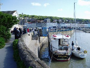
Knightstone
Latitude: 51° 21'N
Longitude: 02° 59'W
Country: England
Ownership: North Somerset Council
Type: Municipal
Usage: Leisure
Contact name: Philip Regan, Seafronts and Events Operations Manager
Telephone no: 01934 634994
E-mail: philip.regan@n-somerset.gov.uk
Website: www.n-somerset.gov.uk/Lei...arbour.htm
About Knightstone
North Somerset Council is responsible for the public slipway and haven at Knightstone Harbour at the north end of the seafront in Weston-super-Mare. Day trips to Steep Holm island operate from the quay. There is also a large wide concrete slipway for leisure craft.The harbour was originally built for the old sailing coal ships back in the 1840s.
Return to Area Map