
Eling
Latitude: 50° 55'N
Longitude: 01° 29'W
Country: England
Type: Unknown
Usage: Leisure, Commercial
About Eling
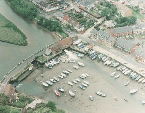
The quay at Eling has been an active harbour going back many hundreds of years with tall-masted ships loading and unloading their goods since medieval times. Today the adjoining industrial wharf is still used for commercial cargo on a regular basis.A tide mill has existed here for centuries, and is mentioned in the Domesday Book, it was built for milling the local flour, and is still producing today, one of a few such mills in Europe and is a favourite tourist attraction.
Next to the mill can be seen wharves where once shipbuilding thrived but is now owned by timber merchants and light industry, while Eling Creek is a popular place for the mooring of private boats. The Anchor Inn, which stands on the wharf, is a popular stop off for those sailing in Southampton Waters.
Return to Area Map